Need a site plan, plot plan, or lot-fit survey for a Houston property project? Whether you are planning an addition, preparing a permit submittal, checking where improvements fit on a lot, or organizing documents for a builder, designer, or contractor, a Houston surveying provider can review your project details and help identify the right next step.
Houston, TX only · Requests may be reviewed or routed to a Houston-area surveying provider.
Houston, TX
Request Help About Site Plan & Plot Plan Survey
Share your property address, the reason for the survey, and any deadline. A Houston surveying provider can review your request and explain the next step.
Reviewed September 2026•Houston Survey Help Editorial Team•Official Texas, local and national sources checked where relevantHow we prepare this guidance
Site Plan and Plot Plan Help for Houston Properties
A site plan or plot plan can help show how a property is laid out and how existing or proposed improvements relate to the lot. Depending on the project, the plan may need to show buildings, driveways, parking, setbacks, easements, access, trees, landscaping, or other site details. For some projects, a current survey or additional field work may be needed before the plan can be prepared or reviewed.
Common Reasons People Request This Service
Common reasons include building additions, remodels, garage or carport projects, pool planning, commercial site changes, lot-fit checks, permit review questions, proposed construction layout, and documentation for architects, engineers, or builders.
When You May Need a Site Plan or Plot Plan
You may need this type of help when a project requires a drawing or survey-related document that shows existing and proposed conditions on the property. The exact requirement can depend on the project type, property records, permit comments, and whether a current survey already exists.
Building Permit or Plan Review
A permit or plan review may require a site plan or related survey information showing the property, proposed work, and how the project fits on the lot.
Additions, Remodels, Garages, or Pools
Home projects that change the footprint of a property may require plan information showing existing structures, proposed improvements, setbacks, and access areas.
Lot Fit and Project Feasibility
A lot-fit or plot plan request may help determine whether a proposed improvement appears to fit within the available property area before design or permitting moves forward.
Commercial Site Changes or Development Planning
Commercial projects may need a site plan for parking, access, proposed improvements, loading areas, landscape information, utility coordination, or development review.
What a Site Plan or Plot Plan May Show
The details included depend on the project, available records, and the purpose of the plan. A simple homeowner plot plan may not need the same level of information as a commercial development site plan or engineering support document.
Information That May Be Included
A site plan or plot plan may show property lines, building footprints, proposed improvements, driveways, access points, parking areas, setbacks, easements, trees or landscaping notes, adjacent streets, paved areas, drainage-related features, and other site information requested by a permit office, builder, designer, engineer, or project reviewer.
Houston Site Plan and Development Review Context
Houston development and permitting work can involve site plans, recorded plats, survey documents, setbacks, parking, access, tree or shrub requirements, and other property-specific details. The City of Houston Planning Department states that development site plans are checked for compliance with items such as parking, tree and shrub requirements, setbacks, and access. A Houston survey provider can review your property details and help determine what survey or plan support may be needed for your details.
Site Plan vs Plot Plan vs Survey: What Is the Difference?
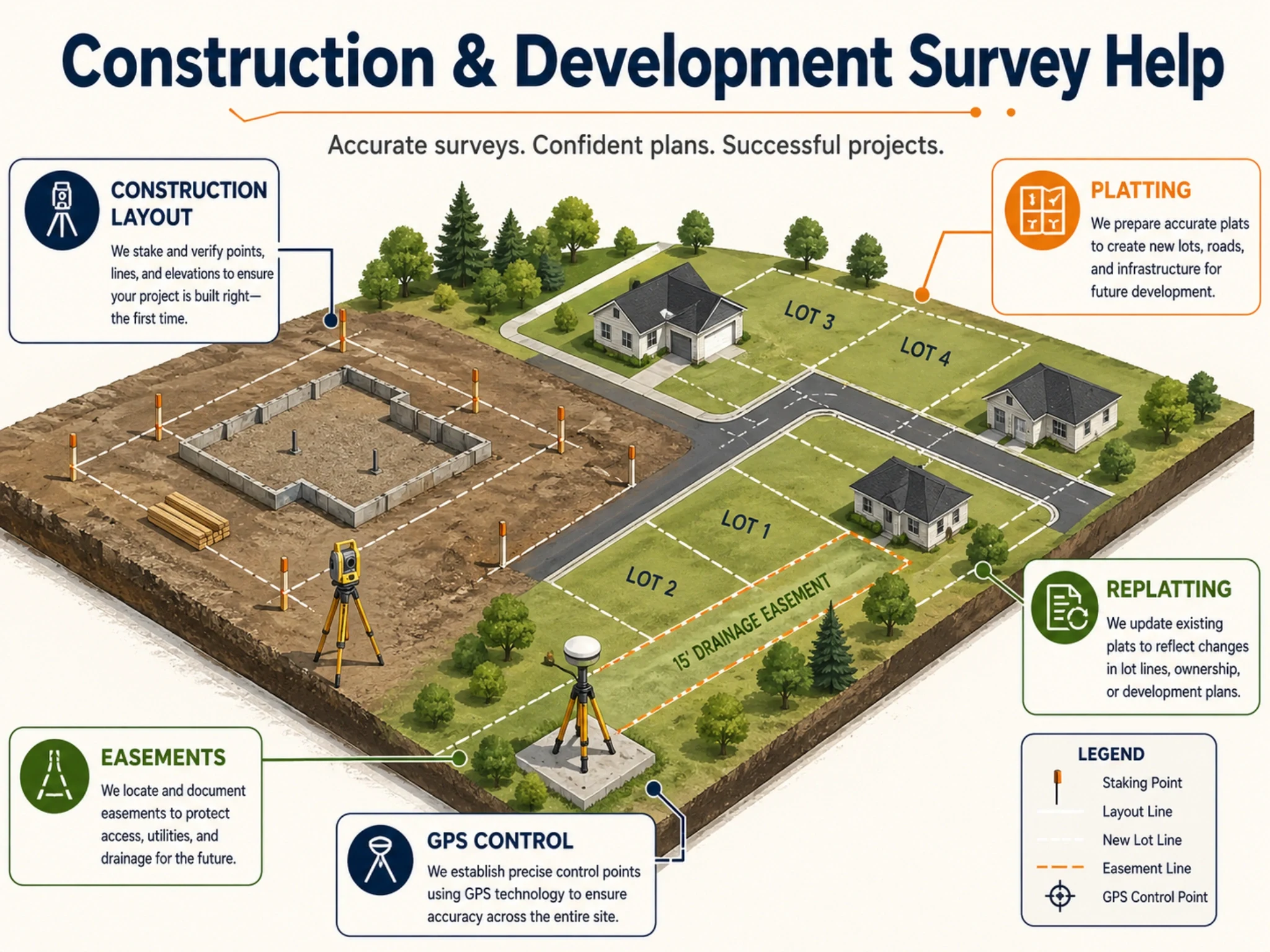
Many property owners use these terms interchangeably, but the required document can depend on the project. A site plan usually focuses on how the property and proposed work are laid out. A plot plan is often used for a simpler property layout or lot-fit need. A boundary survey focuses on property lines. A topographic survey focuses on elevations and site features. Platting or replatting deals with official land subdivision or lot changes. Construction staking marks approved design points in the field.
Use This Page When You Need Plan or Permit Layout Support
Keep the user on this page when the need is a plan-style document, lot-fit check, or project layout support for permitting/design. Route the user to other pages when they need boundary lines, elevation/contour data, official platting, or field staking.
How the Site Plan or Plot Plan Help Process Works
The process starts with the property address, project goal, and any existing documents. The provider can then review whether your details may involve an existing survey, new field work, record research, drafting, or coordination with a designer, engineer, builder, or permit comment.
1Step
1. Share the Property and Project Details
Send the property address, project type, proposed work, deadline, and any permit comments, old surveys, plats, site sketches, architectural drawings, or contractor notes you already have.
2Step
2. Review What Type of Survey or Plan Is Needed
The request can be reviewed to determine whether you need a site plan, plot plan, property survey, topographic survey, platting support, or another related service.
3Step
3. Confirm Scope, Records, and Field Work
Some projects may use existing documents, while others may require record research, property measurements, field work, or drafting based on current site conditions.
4Step
4. Receive Scope & Pricing Help and Next Steps
After your request is reviewed, you can receive guidance on likely next steps, schedule needs, deliverables, and information required before the work begins.
What Affects Site Plan or Plot Plan Survey Cost in Houston?
Cost can vary because a simple plot plan request is different from a commercial site plan, topographic survey, development plan, or permit-driven request. Factors can include property size, project type, required detail level, existing survey availability, field work, drafting needs, urgency, record research, and whether related services such as boundary, topographic, platting, or tree information are needed.
Houston survey resource note
What to Confirm Before Ordering This Survey
For a Houston survey request, the best next step depends on the property address, the reason for the survey, available records, required deliverables, and whether the final document must be prepared or signed by a Texas Registered Professional Land Surveyor.
Required deliverable
Ask whether you need a signed/sealed survey, CAD file, PDF, elevation certificate, plat, staking points, or another specific deliverable.
Records and scope
Share any deed, title commitment, old survey, site plan, plat, flood information, or lender instructions so the scope is not guessed.
Houston context
Floodplain, permitting, title, subdivision, access, and easement questions can change the survey type and the review path.
Use these official resources for research only. Final requirements can depend on the property, project, lender, title company, city, county, or reviewing authority.
Houston Site-Plan Review Context
The City of Houston Planning and Development Department reviews development site plans for requirements that can include setbacks, parking, landscaping and access. Houston does not use conventional zoning, so project teams should confirm the development regulations that actually apply to the site.
Use official records and current agency instructions as verification sources. A web guide cannot determine the professional scope required for a specific property.
Site Plan and Plot Plan Request Scenarios
These examples show how to prepare a clearer request before a surveying provider confirms the project-specific scope.
Typical request scenario
Addition, accessory structure or property improvement
An owner or designer needs a plan showing the property and proposed improvement context. Share the address, proposed work, available boundary information and the permit/reviewer instructions so the needed survey base can be confirmed.
Illustrative workflow — not a client claim or completed-project case study.
Typical request scenario
Commercial development site-plan support
A project team needs a survey-based site plan or existing-conditions base for design review. Provide current plans, required features, setbacks/access questions and the reviewing authority’s submittal requirements.
Illustrative workflow — not a client claim or completed-project case study.
FAQs
Site Plan and Plot Plan Survey FAQs
These answers address common questions about site plan/plot plan intent and route other services with internal links.
It depends on the project. A property survey may show boundaries and existing property information, while a site plan may be used to show proposed work or how improvements fit on the lot. Some projects may require both.
The terms are often used in similar ways, especially for smaller projects, but the required detail can vary. A plot plan is often simpler, while a site plan may include more project, access, parking, landscaping, or development details.
A site plan or related survey information may be needed for certain permit or plan review situations. The exact requirement depends on the project, permit comments, property records, and whether additional survey work is needed.
Send the property address, project type, proposed work, any old survey or plat, permit comments, sketches, contractor notes, and your deadline. The more detail you share, the easier it is to route your details.
If the project needs elevation, contour, drainage, or grading information, a topographic survey may be needed. If the main need is a property layout or proposed improvement plan, this page may be the better starting point.
If you are dividing, combining, reconfiguring, or officially changing lots, platting or replatting may be needed. A site plan does not replace official platting requirements.
Sometimes an old survey may help, but it may not be enough if property conditions changed, the permit reviewer requires updated information, or the project needs current field data. A provider can review what you have.
Related
Related Houston Survey Services
Some requests are better handled through a more specific service or guide page. Use these links if your project has a clear next step.
A Simple Way to Start Your Houston Site Plan Request
If you are unsure what document your project needs, you do not have to guess. Share the project type, property address, and any existing files so your request can be reviewed. The goal is to point you toward the right survey or plan support instead of sending you to the wrong page or service.